
Bretagne Centre Rando
In-app purchases
5K+
Downloads

Everyone
info


About this app
The discreet hills and valleys of central Brittany are a hiking destination apart. From the small Mené mountains to the emblematic lake of Guerlédan passing through the national forest of Loudéac, central Brittany has been protecting and watching, sometimes since secular times, a singular and unsuspected heritage. Thus, the lakes of Guerlédan, Bosméléac, La Hardouinais, the valleys and rivers of Oust and Lié, the canal from Nantes to Brest, the forest of Loudéac,… are all spots allowing family or friends, the practice of "nature sport" and getting fresh air in protected natural spaces.
The mountain bike station, the greenways of central Brittany, the pedestrian and equestrian paths, the trail circuits, etc. allow you to wander in central Brittany and meet villages steeped in history and conviviality. Renowned buildings linked to the singular history of “Les Bretagnes” linen fabrics, majestic religious and megalithic heritage, legendary and mystical sites,… hiking in “central Brittany” is like taking part in an adventure, is to meet a contemporary country with centuries-old Armorican roots, it is to vibrate to the taste of your sports desires!
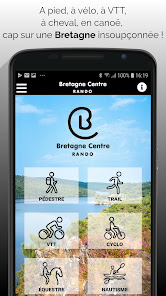
The BRETAGNE CENTER RANDO application is a selection of hiking routes in the southern Côtes d'Armor region (Guerlédan - Loudéac - Merdrignac) in central Brittany.
The routes highlighted on the application were chosen according to their landscaped, natural heritage and sporting interest. They are as diverse as possible to allow a beginner hiker, an experienced sportsman, a family or a tribe of mountain bikers or trail runners to find happiness. The circuits are regularly checked by the delegated hiking federations, the territories and developers and when passing through private properties, the route is agreed.
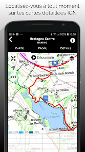
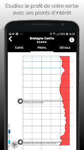
With the application, whether during the ride, arriving at the practice site or at home, the user accesses all the information on the routes; in particular the follow-up of the route and the live profile thanks to geolocation, the download of course maps, access to GPX data, etc.
It is also possible to download the maps for use in offline mode.
The level of the routes as well as the recommendations allow hikers to choose the routes and the sites adapted to their level of practice.
The "go to departure" option leads directly to the starting point of the selected route.
In case of incidents (missing sign, tree across the road, landslide, conflict of use ...) encountered on one of the sites and routes present in the application, it is possible to report them directly on the application.
Note: Continued use of GPS running in the background greatly reduces battery life.
The mountain bike station, the greenways of central Brittany, the pedestrian and equestrian paths, the trail circuits, etc. allow you to wander in central Brittany and meet villages steeped in history and conviviality. Renowned buildings linked to the singular history of “Les Bretagnes” linen fabrics, majestic religious and megalithic heritage, legendary and mystical sites,… hiking in “central Brittany” is like taking part in an adventure, is to meet a contemporary country with centuries-old Armorican roots, it is to vibrate to the taste of your sports desires!
The BRETAGNE CENTER RANDO application is a selection of hiking routes in the southern Côtes d'Armor region (Guerlédan - Loudéac - Merdrignac) in central Brittany.
The routes highlighted on the application were chosen according to their landscaped, natural heritage and sporting interest. They are as diverse as possible to allow a beginner hiker, an experienced sportsman, a family or a tribe of mountain bikers or trail runners to find happiness. The circuits are regularly checked by the delegated hiking federations, the territories and developers and when passing through private properties, the route is agreed.
With the application, whether during the ride, arriving at the practice site or at home, the user accesses all the information on the routes; in particular the follow-up of the route and the live profile thanks to geolocation, the download of course maps, access to GPX data, etc.
It is also possible to download the maps for use in offline mode.
The level of the routes as well as the recommendations allow hikers to choose the routes and the sites adapted to their level of practice.
The "go to departure" option leads directly to the starting point of the selected route.
In case of incidents (missing sign, tree across the road, landslide, conflict of use ...) encountered on one of the sites and routes present in the application, it is possible to report them directly on the application.
Note: Continued use of GPS running in the background greatly reduces battery life.
Updated on
Safety starts with understanding how developers collect and share your data. Data privacy and security practices may vary based on your use, region, and age. The developer provided this information and may update it over time.

No data shared with third parties
Learn more about how developers declare sharing

This app may collect these data types
Personal info and Device or other IDs

Data isn’t encrypted

You can request that data be deleted
What's new
Correctif et ajout de nouveaux parcours


